Update sidebar settings field Excerpt Body for content to show here.
Shop by Category
Create a linklist with title Category Filter for links to show here.
Shop by Price
Create a linklist with title Price Filter for links to show here.
Shop by Brand
Create a linklist with title Brand Filter for links to show here.
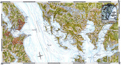
A General Plan of the Chesapeake Bay - Bloodsworth Island to Smith Point
$165.00
The sixth map, arriving at the Maryland-Virginia state line, displays the great Bay at
one of its widest points of over 20 miles. Accordingly, this particular map is characterized by numerous
small islands, as well as larger ones such as Deal Island, and many lighthouses along with the quaint
historic town of Crisfield on the eastern shore.
one of its widest points of over 20 miles. Accordingly, this particular map is characterized by numerous
small islands, as well as larger ones such as Deal Island, and many lighthouses along with the quaint
historic town of Crisfield on the eastern shore.